We believe in empowering individuals and communities through access to data, technology, and capacity development opportunities, enabling them to take control of their lives and futures.
.
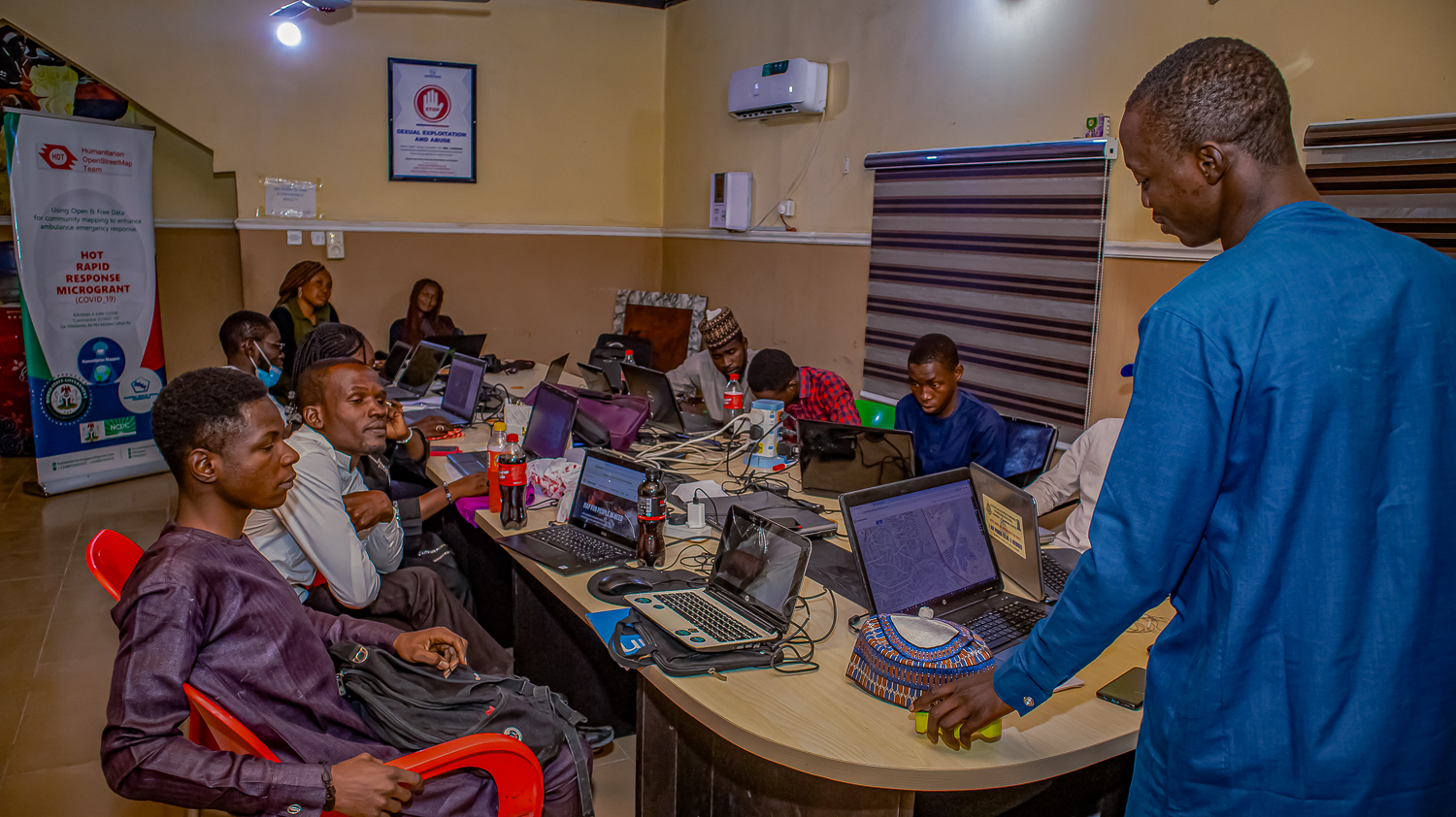
Humanitarian OpenStreetMap Team (HOT) Rapid Response Microgrant: COVID19. Problem Statement and Project Objectives.
The Lake Chad region (Nigeria, Chad, Cameroun, Niger) has witnessed insurgency attacks since 2013, which has greatly affected the people of the region, especially children and women. Currently, the BAY (Borno, Adamawa, Yobe) states are the most affected. Given, the already degenerated socio-economic and health conditions of the internally displaced persons in northeastern Nigeria, it is crucial to deploy sustainable solutions that will mitigate the effect, especially with the current COVID-19 pandemic.
Intervention and Deliverables.
Hence, the use of collaborative mapping using the OpenStreetMap platform to train community people to identify and map their communities and infrastructures especially those related to health and emergency & displacement such as roads, health facilities, isolation centres, safe spaces, etc. These data will be utilized by the community and institutions to respond to their needs. For instance, the state COVID-19 task force manages cases and referrals through efficient utilization of the OSMAnd navigation app by ambulance drivers while responding to the transfer of patients. To ensure sustainability and ownership of this project, we identified and met with these stakeholders: Albaraka Health Spring Foundation (AHSF), and the COVID-19 Task Force team, the former being our local implementing partners while the latter being the Government response team on COVID-19. Over 30 community mappers have been trained on the use and benefit of OpenStreetMap, 5 field officers on data collection and 7 drivers on the use of OSMAnd for navigation and mapping.
Over 2,000 buildings, 950km of roads, 1000 health facilities, 1,264 amenities (IDP camps, schools, banks, etc.), and COVID-19 infrastructures (point of entry, testing centres, etc) were digitized. A youth mapper association was created within the University of Maiduguri while that of Ramat Polytechnic is in the pipeline.
Satellite Imagery for Social Good - Nigeria.Client: The West and Northern Africa Hub (WNAH); Implementation Level: LGA, State.
Problem Statement and Project Objectives.
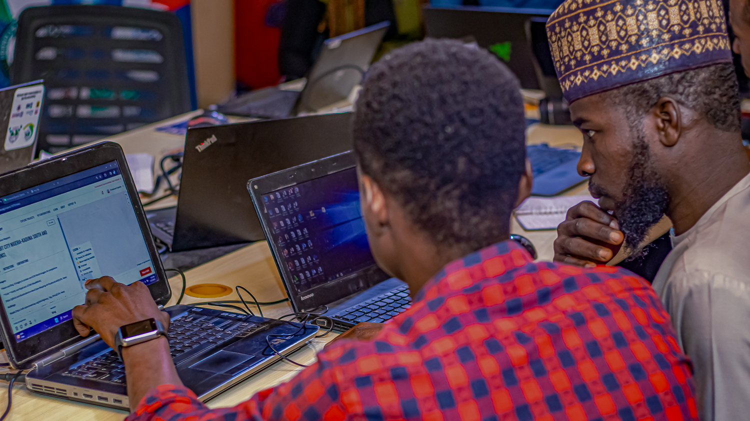
Universally, data remains a key factor in making decisions, however, the important of geospatial data and access to it cannot be overemphasized. To this end, the Humanitarian OpenStreetMap Team Open Mapping Hub for the West and Northern Africa Region in conjunction with Humanitarian mappers, is mapping building prints in the northeast states of Nigeria with a focus on Adamawa, Borno, and Yobe State.
Intervention and deliverables.
To support the mapping of these building footprints, Humanitarian mappers’ community mappers mapped buildings using JOSM/Raid ID, as well as provided contextual knowledge of the area to have accurate mappings. Leveraging on our mapping experience in various HOT tasks and projects, we engaged with organizations/institutions in interest to create awareness, visibility, room for collaboration, partnership, and feedback, thereby providing them with the platform to harness the benefits of the project, especially in the social-economic development of the citizens.
Over 1.8 million AI-generated and human-verified building footprints were mapped by 15 mappers and 2 validators across selected northern states in Nigeria. Capacity development for on the generated data and existing health datasets for improvement on the quality of microplanning and health campaigns for the over 35 stakeholders (local government staff and other stakeholders)
Sokoto Emergency Routine Immunization Coordination Center (SERICC). Client: Sokoto State Government, Nigeria; Implementation Level: Ward, LGA, State.
Problem Statement and Project Objectives.
Routine Immunization (RI) is highly important for achieving protection of children against vaccine-preventable diseases. The continuous improvement of the processes and channels through which targeted children are identified, planned for and accessed are critical to achieving the overall RI goal.
To this end, Sokoto state SERICC with the assistance of GIS consultants is improving the RI process through the use of geographic information systems (GIS) to integrate, map and improve on existing data of settlements, health facility location, population and road networks to produce a more robust settlement, health facility master list and detailed catchment area/distance maps with population estimates, which can be used for the micro-planning plan thus ensuring no child is left behind.
Intervention and deliverables.
In providing solutions to this, the following major processes were embarked upon: Identification of the datasets: State Microplan, WHO and VTS lists; Desk review of datasets, harmonization & reconciliation: which is the process of bringing together datasets and transforming them into one robust single data list; Data reconciliation and harmonization: identify the variance in datasets between VTS, WHO and Sokoto State Microplan settlements and health facilities list; Data analysis and Modelling
Distance Matrix generation; Population estimation generation; Map production; arranging refined data and map elements visually for ease of identification and interpretation.
The deliverables delivered for this project include a master list of settlements with a unique global identifier, a master list of health facilities with a unique global identifier, a population estimate at the settlements area level, a distance matrix between health facilities and settlements to determine session (fixed, mobile and outreach session).
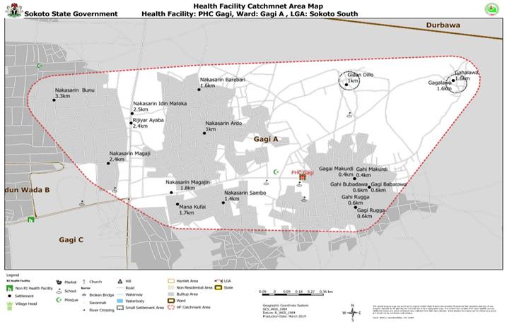
Routine Immunization Health Facility Catchment Mapping.
Map production of 530 health facility Catchment Area Map, one state health facility map and 23 LGAs Health Facility Map
Sample Output: Routine Immunization Health Facility Catchment Mapping showing settlements with their distances in Sokoto State.
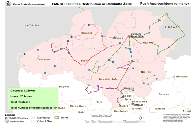
Route Cost Optimization for the Distribution of MNCH Commodities in Kano. Client: Kano State Ministry of Health, Nigeria; Implementation Level: LGA, State.
Problem Statement and Project Objectives.
Kano State has an estimated population of 12.5 million, and records a maternal mortality rate (MMR) of 1,025 deaths per 100,000 live births: a figure substantially higher than the national average of 576 deaths per 100,000 live births. The neonatal mortality rate of 55 per 1,000 live births, also exceeds the national average of 37 deaths per 1,000 live births.
Evidence suggests that many of these deaths can be prevented with access to life-saving maternal, neonatal, and child health (MNCH) commodities and these gaps were identified: Facilities were not able to stock some commodities at the Minimum Stock level, although commodities were available at that State; some facilities do not replenish their stock regularly; Opportunities were identified to improve network distribution for MNCH commodities.
Intervention and deliverables.
We supported CHAI and Village Reach through the Kano State Ministry of Health to improve supply chain performance, by developing a transport route optimization plan for the distribution of MNCH commodities in Kano. This will reduce the cost of transportation and man hours and will support the State in harmonizing all vertical supply Chain.
We were able to come up from our insight analysis with three optimal scenarios:
· Pull Approach (one-to-one): The facilities go to the zone to collect their commodities and return to the facilities hence the relationship is one-to-one.
· Push Approach 1(one to many): The warehouses deliver commodities to the facilities using their operational vehicles, this is scheduled and organized. This is based on the proximity of the facilities to each other, the maximum kilometer expected to be travelled per day is 300km.
· Push Approach 2(one to a cluster): The warehouses deliver commodities to an agreed facilities/LGA, where other facilities can pick up from the agreed facilities/LGA.
We recommended the State should go ahead with its plan to decentralize the distribution of FMNCH commodities and a mixed Approach should be used where the facility makes a request and the warehouse delivers
Sample Output:
Route Optimization for the Distribution of MNCH Commodities in Dambatta Zone, Kano (Push Approach).
Humanitarian OpenStreetMap Team (HOT) Rapid Response Microgrant: COVID19.The data was standardized, reconciled & harmonized with an existing database, and then analyzed. Visualization was done for the data across these states: Ebonyi, Ekiti, Imo, Osun, and Oyo.
Client: HOT; Implementation Level: LGA, State.
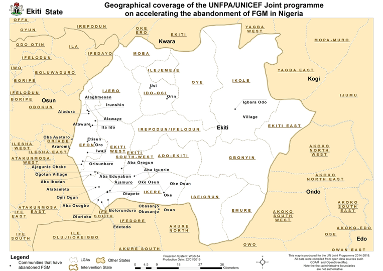
UNFPA/UNICEF Joint Programme on accelerating the abandonment of FGM in Nigeria
Client: UNFPA; Implementation Level: LGA, State
Problem Statement and Project Objectives.
Data have been collected by the officer, however, some of the data were incomplete due to incomplete data collection. Also, there is a need for analysis and visualization of the data. The project was to support UNFPA/UNICEF in accelerating the abandonment of FGM in Nigeria in Ebonyi, Ekiti, Imo, Osun, and Oyo.
Intervention and deliverables.
Sample Output: UNFPA/UNICEF Joint Programme for communities that declared abandonment of FGM.
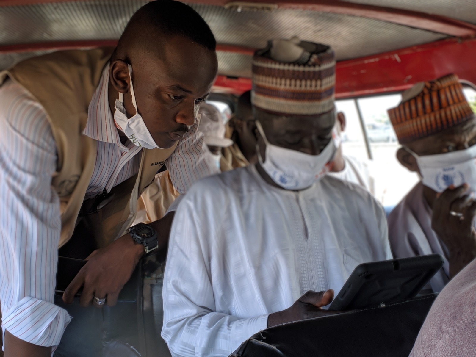
Humanitarian OpenStreetMap Team (HOT) Rapid Response Microgrant: COVID19
Client: HOT; Implementation Level: LGA, State.
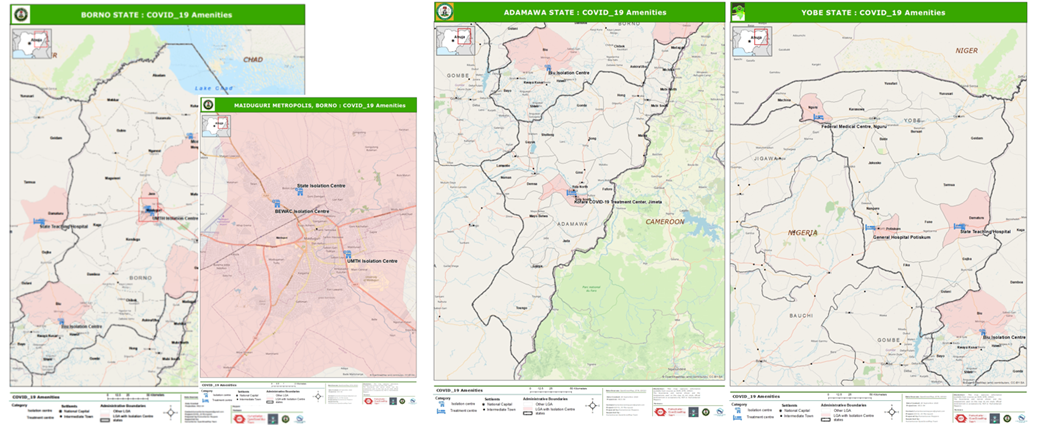
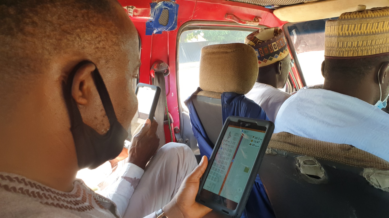
Using OpenStreetMap data to support emergency ambulance response service and mapping of COVID_19 amenities in the northeast, Nigeria.
Problem Statement and Project Objectives.
The Lake Chad region (Nigeria, Chad, Cameroun, Niger) has witnessed insurgency attacks since 2013, which has greatly affected the people of the region, especially children and women. Currently, the BAY (Borno, Adamawa, Yobe) states are the most affected. Given, the already degenerated socio-economic and health conditions of the internally displaced persons in northeastern Nigeria, it is crucial to deploy sustainable solutions that will mitigate the effect, especially with the current COVID-19 pandemic.
Intervention and deliverables.
Hence, the use of collaborative mapping using the OpenStreetMap platform to train community people to identify and map their communities and infrastructures especially those related to health and emergency & displacement such as roads, health facilities, isolation centres, safe spaces, etc. These data will be utilized by the community and institutions to respond to their needs. For instance, the state COVID-19 task force manages cases and referrals through efficient utilization of the OSMAnd navigation app by ambulance drivers while responding to the transfer of patients. To ensure sustainability and ownership of this project, we identified and met with these stakeholders: Albaraka Health Spring Foundation (AHSF), and the COVID-19 Task Force team, the former being our local implementing partners while the latter being the Government response team on COVID-19. Over 30 community mappers have been trained on the use and benefit of OpenStreetMap, 5 field officers on data collection and 7 drivers on the use of OSMAnd for navigation and mapping.
Over 2,000 buildings, 950km of roads, 1000 health facilities, 1,264 amenities (IDP camps, schools, banks, etc.), and COVID-19 infrastructures (point of entry, testing centres, etc) were digitized. A youth mapper association was created within the University of Maiduguri while that of Ramat Polytechnic is in the pipeline.
We value collaboration and partnership with communities, organizations, and governments, recognizing that collective action is essential for achieving meaningful impact and lasting change.
.png)
.png)